See Prague - Matrei a Matrei - LucknerhausGPS (in Czech).
Phone +43 4876 8555. Photo 2.
There are two big free parking places. We usually sleep there.
Distance - 5,3 km. Superelevation 890 m.
Time:
Up: signpost at LucknerhausGPS 3:15, our time 2-2:30 (2003 and 2009). To LucknerhütteGPS (2241 m) 45-50 min.
Down: signpost at StüdlhütteGPS 2:30, our time 1:20 (2009, we hurried because the ascent and departure to Prague was on the same day).
| elevation | 2802 m |
| coordinates | N47.05475 E12.6810329 |
| Alpenverein | yes |
| cell phone signal | may be poor inside, goog outside |
| drinking water | free |
| hot water | yes |
| shower | no |
| toilet | flushdown, only 4 places |
| slippers | enough for everybody |
| blankets | yes |
| hut sack | requested but not enforced |
Normal route (as part of the Hoch Tirol route - in Czech, in descent after climbing Pallavicini gully, Stüdlgrat and Northwest ridge - see below)
Pallavicinni gully (photos from unsuccessful atempt in June 2001, successful ascent in September 2001 - only description of historical ascent, all in Czech)
Southwest ridge (Stüdlgrat) (description of the route, photos, in Czech)
Northwest ridge (detailed description of the route, schemes, photos, in English)
Image 1. GPS tracks and waypoints. Projection into Garmin vector map Austria Topo.
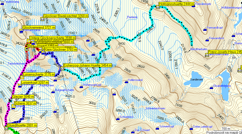
Blue line - GrossglocknerGPS normal route, azure line - ascent to GrossglocknerGPS from Pasterzenboden, violet line - Stüdlgrat, red line - Northwest ridge, green line - ascent to StüdlhütteGPS from LucknerhausGPS.
Image 2. GPS tracks and waypoints. Projection into Alpenverein Map.
 |
Show waypoints Hide waypoints - F5
The same color coding: blue line - GrossglocknerGPS normal route, azure line - ascent to GrossglocknerGPS from Pasterzenboden, first violet line - Stüdlgrat, red line - Northwest ridge, second short violet line - firn I-gully to GrögerschneideGPS, short yellow line - bypass of the Lower NW ridge - over the right arm of the Y-gully. See Image 3.
Image 3. Firn gullys in the south face of the Lower NW ridge. Satellite image from Google.
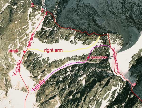
This face is described in End-Peterka guide. But - in our opinion - none of the formation mentioned (Draschrinne, Grögerrinne or indentations of the Lower Glockner SaddleGPS) is exactly defined and we use own words. The left gully has shape of the letter Y. The place marked "neck" may not have snow and than it is more difficult or requires protection. Left arm goes to Lower Glockner SaddleGPS (Untere Glocknerscharte, red line). It is reasonable to give some simple name to the Y-gully with its left arm and South gully (Südrinne) will do the job. The Lower Glockner SaddleGPS has three indentations. End-Peterka is probably considering No 1 and No 3 as right and left (No 3 is however clearly higher so only No 1 is true saddle). Lower NW Ridge beginns in the right indentationGPS (No 1, first bolt). It is easy to traverse from 2 to 1 (own experience). The right - more horizontal - arm enables firn acces to the saddle between TeufelshornGPS and GlocknerhornGPS (yellow line, own previous experience, Photo 12). It is also considered to be bypass to the Lower NW ridge and access to the Upper NW ridge. In that case it crosses rock band coming south from GlocknerhornGPS and reaches GrögerschneideGPS (difficulties?, End-Peterka warns against traversing GlocknerhornGPS from south but it may be different level). I-shaped gully represents another way how to get to GrögerschneideGPS. The ascent however for some (probably good) reason leaves I-gully and crosses vertically to the right arm of the Y-gully. We don't know where exactly is this connection. We placed this track into small firn band visible on satellite view. It can be more to the left in the rock according to the picture in End-Peterka. This place is not visible from access route on Teischnitzkees nor from the level of the BergschrundGPS. See also Photo 4 and Image 4.
Image 4. Satellite view from Live Map.
Live map has different and more snowy satellite view than Google. Firn connection between I-gully and right arm of the Y-gully is better visible. It also displays better the place on the Upper NW ridge marked "rib". Traversing GrögerschneideGPS is easy horizontal two-pitch walk on the firn. The third pitch is steep and firn ends where small rib connects to the NW ridge from the north (Photo 13). GrossglocknerGPS on the Live map (zoom to get the same magnification).
Image 5. GPS tracks and waypoints on the NW ridge. Projection into Google sattelite view.
 |
The BergschrundGPS may not be easy to cross. We used the place where it is filled-up with the snow falling from I-gully (Photo 7). Similar place was more to the left below the Y-gully.
Track list.
| Name in GPS | description | km | colour | source |
| Fr-Jos-Haus | Fr-Jos-HausGPS - GrossglocknerGPS | 8,3 | azure | Alpinkoordinaten.de |
| I-gully | BergschrundGPS - saddle between TeufelshornGPS and GlocknerhornGPS | 0,3 | violet | Google Maps |
| NormalRoute | StudlhutteGPS - GrossglocknerGPS | 4,1 | blue | recorded |
| NWRidge | StudlhutteGPS - GrossglocknerGPS over Northwest ridge | 3,4 | red | recorded |
| Rarm | Sudrinne - saddle between TeufelshornGPS and GlocknerhornGPS | 0,2 | yellow | Google Maps |
| Studlgrat | StudlhutteGPS - GrossglocknerGPS over Stüdlgrat | 2,9 | violet | Alpinkoordinaten.de |
| Studlhutte | LucknerhausGPS - StudlhutteGPS | 5,3 | green | recorded |
Click on coordinates to see position in Google Maps. Coordinates have format of Garmin desktop application Mapsource (in decimal degrees). You can directly copy and paste data into waypoint properties window. All data, including tracks, can be however downloaded as a single file (see below). "Measured" means our recording. Alpin-koordinaten.de = www.alpin-koordinaten.de
All data contain 43 waypoints and 7 tracks.
Recorded tracks are often edited - obvious mistakes in measurement (jumps), lumps at the sites of stops etc. are removed. Tracks are also sometimes combined from pieces from other tracks - e. g. to pick just one recording for section covered by more tracks or to create track with desired course.
Consider that your GPS may not be able to absorb all this data. Each devise has its own limitation for number of waypoints, tracks and number of points in track (in eTrex Vista - 500 waypoints, 20 tracks and 500 points/track). You can join the tracks together to decrease their number. Process called filtering helps to decrease the number of points in track.
The file Grossglockner_GPS.zip contains two files, both in gpx format. The first file contains all data with waypoint names shortened for GPS, the second file has waypoints with full names.